 Built In Oasis


AI City Expansion Engine
Functional DemoLocation intelligence that scores ZIP codes by industry-specific expansion opportunity.
A 2D and 3D site-planning simulator that shows what fits on a parcel of land.
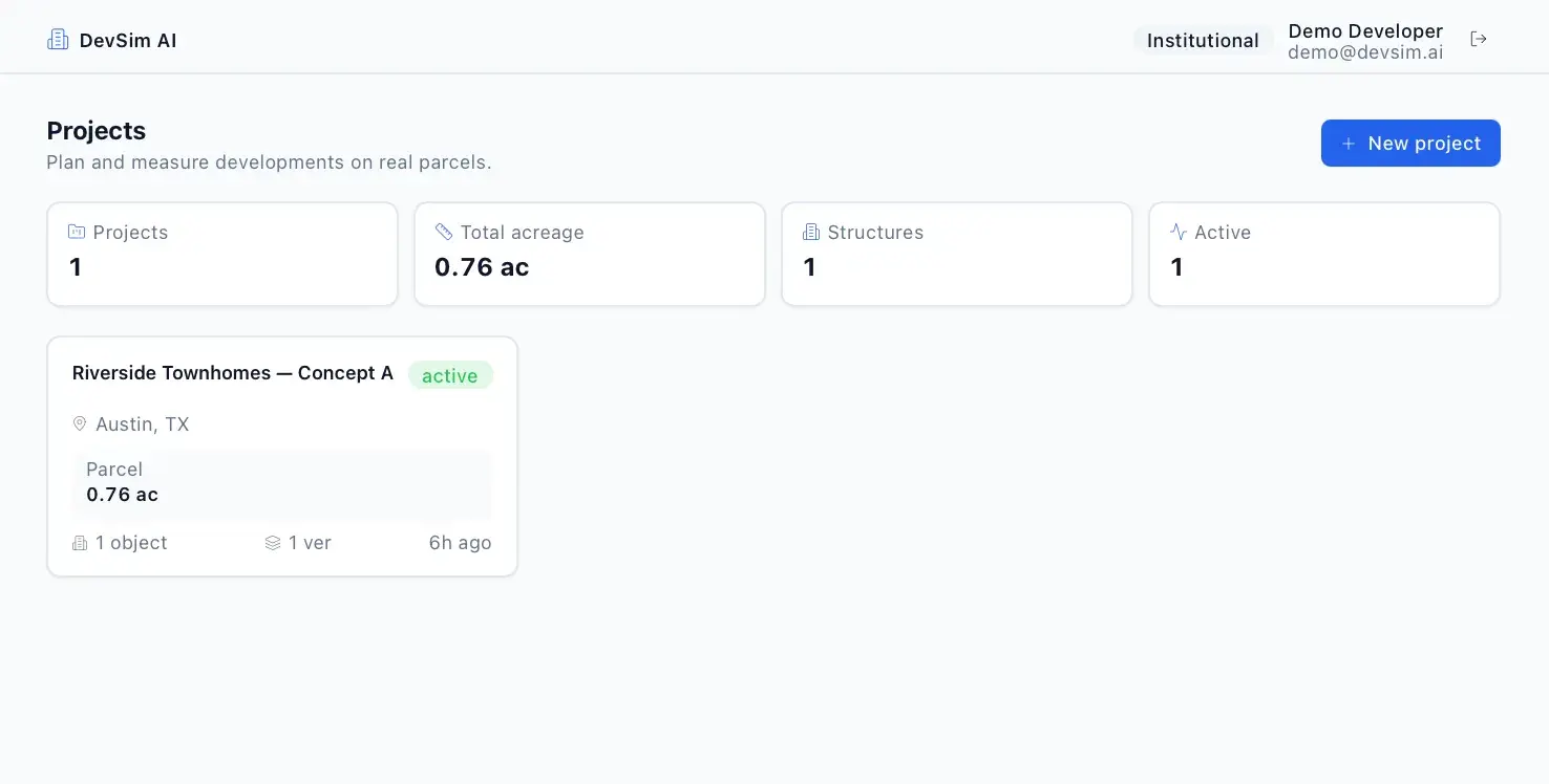
Early-stage real estate feasibility is hard to answer quickly: users struggle to visualize what can realistically fit on a parcel without slow CAD or GIS software, generic map-annotation tools, or guesswork that lacks real measurements. DevSim AI exists to make that answer visual, fast, measurable, editable, and exportable.
Built for Small home builders, residential/land/multifamily developers, real estate investors, land brokers and agents, architects and civil engineers doing early feasibility, landowners, and private-equity real estate groups.
DevSim AI lets users search a parcel, load satellite imagery, and design conceptual development layouts with accurately scaled 2D buildings, roads, driveways, parking, and green space. Buildings are generated from square footage and floor configuration, and a shape slider and rotation preserve area while changing proportions. Manual setback rules produce a buildable-area overlay and human-readable warnings, and a Fit Check Score plus an analysis dashboard report parcel usage, density, and coverage live. An optional 3D massing mode extrudes the same 2D plan, and projects support versioning, export, and an AI assistant. It is a multi-tenant SaaS with tiered plans.
The heart is a pure geospatial geometry engine (Turf.js, GeoJSON) that generates building footprints from area, preserves area under shape changes and centroid rotation, buffers road centerlines into measurable polygons, and detects parcel containment and overlaps. It converts 2D footprints into accurate 3D extrusions (Three.js), computes a live Fit Check Score, and enforces plan limits through Stripe billing with Upstash-backed rate limiting.
This is not a map demo or a drawing tool. It is a real estate development simulator that answers one question: what can I realistically fit on this parcel of land?
2D site planner
Interactive canvas over satellite imagery with parcel boundary overlay.
Parcel search and loading
Geocodes an address, finds the parcel, and calculates its area.
Building creation engine
Generates an accurately scaled footprint from entered square footage and floors.
Advanced building configuration
Up to 25 floors with floor plates, podium, tower, and step-back settings.
Shape ratio sliderArea-preserving shape slider
Changes width-to-depth proportions while holding footprint square footage constant.
Rotation and duplication
Rotates around the centroid and duplicates while preserving area and metadata.
Road and driveway engine
Draws centerlines and buffers them into measurable polygons by width.
Parking and green space
Adds parking and open-space objects with area calculation.
Site rules and setbacks
Manual setbacks and limits generate a buildable-area overlay as guidance.
Fit Check ScoreFit Check Score
0-100 score summarizing whether the layout works.
Analysis dashboard
Live parcel, building, road, density, and open-space metrics.
Project saving and versioning
Autosave, manual save, and alternate layout versions with metric comparison.
3D massing mode
Extrudes 2D buildings into massing blocks with height and floor labels.
Export and presentation mode
PDF, image, project summary, and view-only share links.
AI assistant layer
Explains layout, warnings, and Fit Check Score with verification disclaimers.
Geometry engine
Typed, isolated spatial utilities for area, centroid, rotation, and containment.
Fit Check Score
Whether buildings and roads stay within the parcel boundary.
Buildings overlapping each other lower the score.
Objects crossing setback areas reduce fit.
Coverage relative to the maximum lot coverage rule.
Roads meeting minimum width and staying inside the parcel.
Whether minimum open space is met.
Units per acre relative to the concept.
Building height against the maximum height rule.
The count and severity of active warnings.
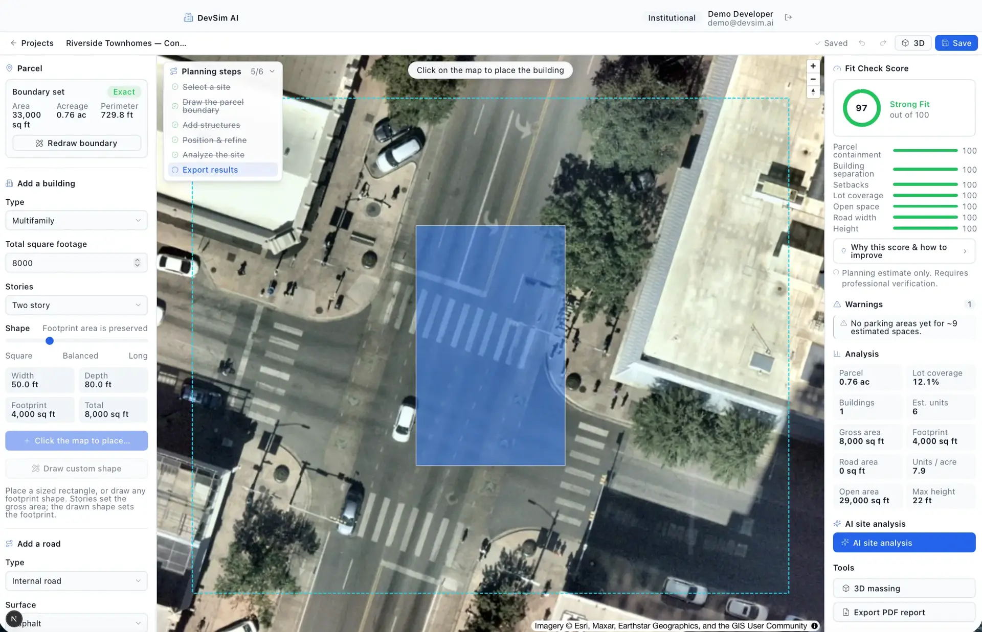

A Next.js and React app with Prisma over PostgreSQL, a MapLibre satellite map for the 2D planner, Turf.js for geometry, and Three.js for 3D massing. NextAuth handles authentication, Stripe handles tiered billing, Upstash Redis rate-limits AI calls, Resend sends password-reset email, and Claude powers the optional AI assistant.
Location intelligence that scores ZIP codes by industry-specific expansion opportunity.
Strategy-based real estate deal-analysis SaaS that models rentals, flips, BRRRR, and creative-finance deals in minutes.
Enter a property once and compare flip, hold, Airbnb, seller finance, BRRRR, and wholesale exits side by side.
Start a project and reference this one — the conversation begins with what you have already seen.
Start a project